
Saturday, 15 July 2006
131-1
Terrestrial and Orbital Spectral Models for the Determination of Tropical Soil Attributes.
TERRESTRIAL AND ORBITAL SPECTRAL MODELS FOR THE DETERMINATION OF TROPICAL SOIL ATTRIBUTES
José Geraldo de A. Sousa Junior; José A. M. Demattê; Aline M. Genú; Marco A. M. Bortoletto
Department of Soil Science and Plant Nutrition, University of São Paulo - Escola Superior de Agricultura “Luiz de Queiroz”
Av. Padua Dias, 11 – PO Box 09, 13.418-900, Piracicaba, São Paulo – Brasil
jgsousa@esalq.usp.br; jamdemat@carpa.ciagri.usp.br; amgenu@esalq.usp.br; mamborto@yahoo.com.br
The increasing in use of precision agriculture by farmers has been promoted changes in crop yields, but this practice demands a large number of soil chemical analysis and quick results. The traditional methods for soil attributes quantification are complex, expensive, and slow generating a large amount of chemical residues that can contribute to environmental contaminations. Thus, the use of electromagnetic radiation by sensors can be an alternative. The objective of this work was estimate granulometric attributes of soil from Ibaté and São Carlos, SP, through multiple linear regression equations generated with reflected electromagnetic information collect by sensors installed in laboratory and satellite. It was collected 319 soil samples and these points were georeferenced. The soil samples were evaluated by laboratory sensor (FielSpec: 450-2500 nm) and orbital image (ASTER). Spectral models were elaborated for both acquisition levels. The models were used to determine the attributes on unknown samples. The time and cost analysis considered the system used for soil analysis. The conclusion was that is possible to quantify clay (R² = 0.69) (Figure 1a) and sand (R² = 0.53) content using the reflected electromagnetic energy measures by terrestrial sensor. The orbital sensor showed good results to predict coarse sand (R² = 0.45), total sand (R² = 0.41), and clay (R² = 0.34) (Figure 1b). It was verified that the attributes analysis by sensors can be cheaper and faster than the traditional method for soil analysis. The utilization of remote sensing showed the possibility to quantify soil attributes with several benefits, i.e., minimum sample preparation, faster analysis, simultaneous determination of several soil constituents, indestructible soil sample analysis, no use of toxic chemical reagents to humans and environment.
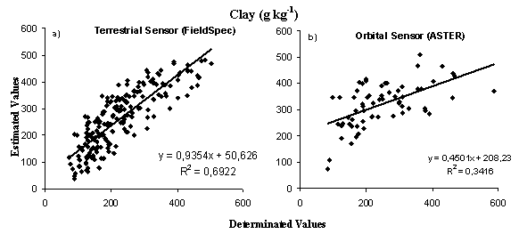
Figure 1 – Comparison between clay content determinate by conventional chemical analyses and remote sensors techniques
Back to 1.5A Diffuse Reflectance Spectroscopy, Soil Sensing, Remote Sensing and Image Analysis - Poster
Back to WCSS
Back to The 18th World Congress of Soil Science (July 9-15, 2006)