Monday, 10 July 2006
6-7
Pedogeochemical Mapping of the Barcelona Province (Catalonia, Spain): Interdependence between Altitude, Soil Texture, pH, Organic Carbon, CaCO3 and Potentially Toxic Elements.
Jaume Bech1, Maria Sokolovska2, Pedro Tume3, Pedro Sanchez4, Ferran Reverter1, Rafael Delgado5, Lluís Longan6, Alejandro Lansac1, Aleix Puente1, and Toni Oliver1. (1) Univ de Barcelona, Avda. Diagonal 645, Barcelona, 08028, Spain, (2) Forest Research Institute, Blvd. Sv. Kliment Ohridski Nr.132, Sofia, Bulgaria, (3) Facultad de Ingeniería, Univ Católica de la Santísima Concepción, Casilla 297, Concepción, Concepción, Chile, (4) Depto de Estadística, Facultad de Biología, Univ de Barcelona, Avda Diagonal 645., Barcelona, Spain, (5) Depto de Edafología, Facultad de Farmacia, Univ de Granada., Campus Universitario la Cartuja 18071, Granada, Spain, (6) Soil Science Chair. Fac. of Biology. Univ de Barcelona, Avda Diagonal 645, Barcelona, Spain
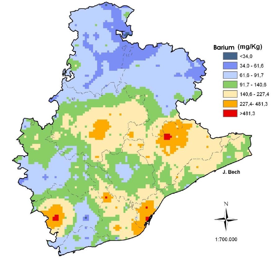
Soils are essential components of the environment, the basis of terrestrial ecosystems and a crossroad of the biogeochemical cycles in the biosphere-litosphere interface. Therefore soil quality must be preserved. The contents and spatial distribution of Potentially Toxic Elements (PTE) depends on the parent materials, the soil types and different soil uses. The aim of this study is to estimate the possible interdependence between altitude, texture, pH, organic carbon, CaCO3 and the concentration and distribution of PTE in the soils of the Barcelona Province, with a surface of 7731km2. The litology is varied: granites and paleozoic shales predominate in SE-E and mesozoic and cenozoic limestones, dolomites, marlstones and sandstones in the rest of the province. The main soils are Xerorthents, Haploxerepts, Haploxeralfs, Haploxerolls and Xerofluvents. 323 top soils samples (0-20 cm) were collected at 5 Km intervals on a regular grid, dried and sieved (<2mm). General soil properties were analysed by standard methods. Aqua regia digests (DIN 38414-S7) of Cr, Ni, Cu, Zn, Ba, and Pb were determinated by Polyscan 61E Spectrometer (ICP-ES). Statistical treatment of data was carried out using the SPSS 12.0 and Statgraphics Plus 5.1. To obtain a robust summary of the dataset we applied Exploratory Data Analysis (EDA) techniques because they do not depend on assumptions of data distribution, but are strongly based on order statistics (median, quartiles, etc.) and the use of graphics (box-plot, histogram and one dimensional scattergram, etc.) to detect unusual data behaviour. The ESRI ArcView 9.0 Desktop was used for colour mapping. The classes chosen to represent the data were percentiles (5th, 25th, 50th, 75th, 90th, 98th), except for pH and the texture classes. The smoothed maps were drawn using the inverse distance weighted-IDW. 15 Km was chosen as search radius and 1 was chosen as a power value. An example is the total Barium content (mg•Kg-1 dry top soil) IDW map.
Back to 1.2P Interdependency of Soils and Soil Scapes - Theater
Back to WCSS
Back to The 18th World Congress of Soil Science (July 9-15, 2006)
