Saturday, 15 July 2006
126-2
Properties and Classification of Volcanic Soils derived from the 10th Century Eruptive Deposits in Changbai Volcano Area, Northeast China.
Hitoshi Kanno1, Tsuyoshi Miyamoto2, and Masami Nanzyo1. (1) Graduate School of Agricultural Science, Tohoku Univ, 1-1 Tsutsumidori-Amamiyamachi, Aoba-ku, Sendai, Japan, (2) Center for Northeast Asian Studies, Tohoku Univ, Kawauchi, Aoba-ku, Sendai, Japan
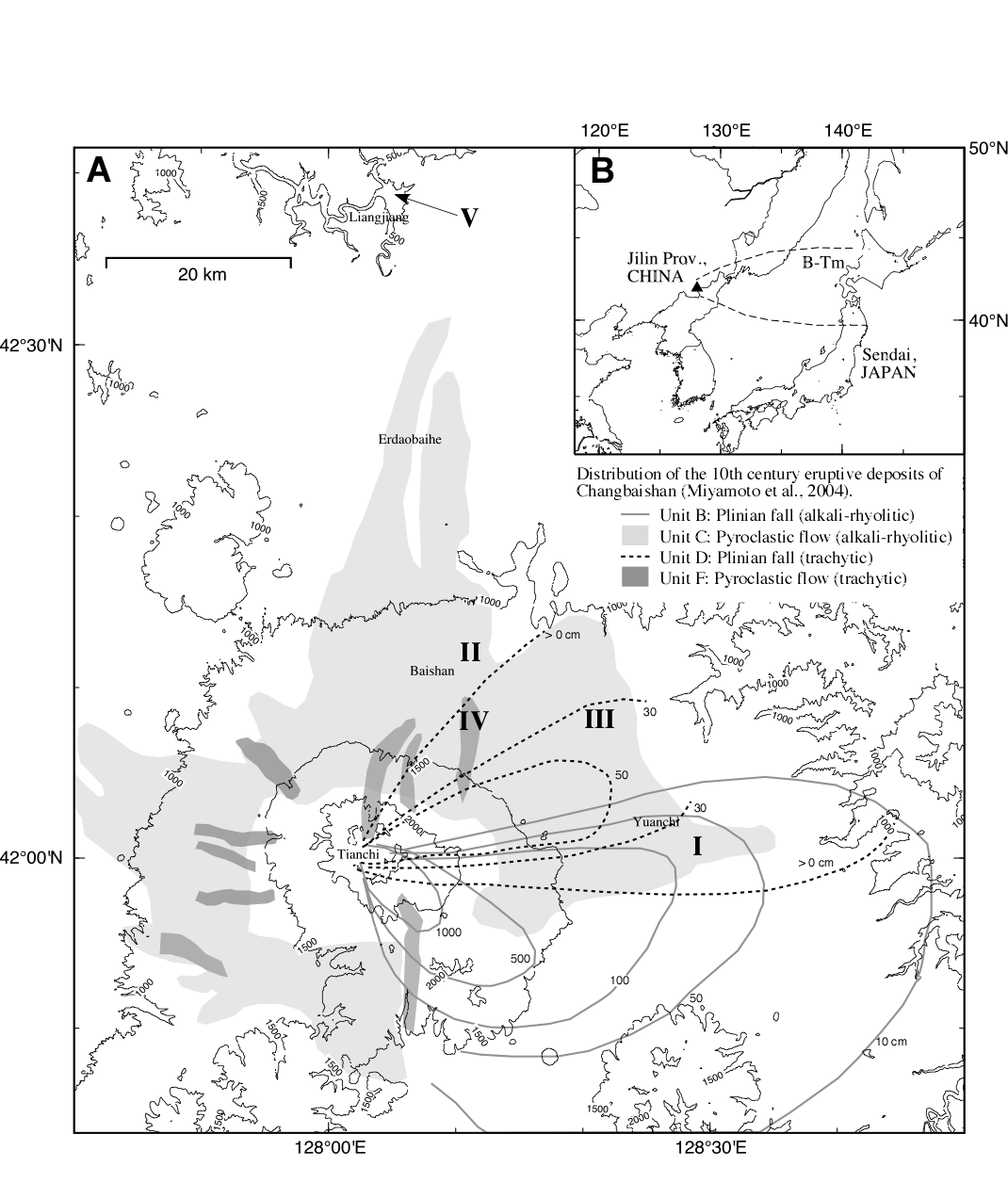
Changbaishan (Baitoushan), locating on the border between China and North Korea, is one of the famous volcanos in China. The 10th century eruption of Changbai volcano was one of the largest volcanisms in the last 2000 years (Machida et al., 1990). The ejecta (B-Tm: Baitoushan-Tomakomai ash) was found also in northeast Japan, more than 1,000 km from the source (Machida and Arai, 1992). In this paper, we examine the properties and classification of volcanic soils in Changbai volcano area. Study area is mainly located on the northeastern slopes of Changbaishan in the eastern part of Jilin province. According to the stratigraphy of the 10th century eruption and unevenly distribution of the ejecta (Miyamoto et al., 2004), we distinguished five groups of volcanic soils by the major parent material as follows: soils from the trachytic plinian fall over the light-colored alkali-rhyolitic plinian fall (group I), the light-colored alkali-rhyolitic pyroclastic flow (group II), the trachytic plinian fall (group III), the dark-colored trachytic pyroclastic flow (group IV) and lahar (mudflow) deposit (group V). Figure shows selected five pedons based on the group of volcanic soils described above. These pedons are located at almost the same elevation (1.1 to 1.2 km above sea level) and climate condition such as precipitation (840 to 890 mm per year) and annual mean temperature (0.9 to 0.4 degrees Celsius) except in the pedon V. All pedons were characterized by sandy or gravelly texture, A/C type of soil horizon sequence and low acid oxalate-extractable Al+Fe content. Based on the world reference base for soil resources (FAO, ISRIC and ISSS, 1998), many horizons met some criteria of vitric horizon (Alo+1/2Feo > 0.4% or P retention > 25%), while considerable horizons fell within the range of tephric soil material (Alo+1/2Feo < 0.4%). Clay contents of most soil horizons or layers were less than 10%. Pedon I and III derived from thick plinian fall deposits classified Tephric-Endoskeletic Regosol and Vitric-Endoskeletic Andosol, respectively. Thick pyroclastic flow deposits formed Tephric Regosol (pedon II) and Vitric-Endoleptic Andosol (pedon IV). Lahar deposits of pedon V also formed Tephric Regosol (pedon V) under relatively high temperature and a little precipitation. These results of soil classification indicate that many soils in Changbaishan, whose soil age would be more than 1000 years old, still remain at the initial stage of pedogenesis. The cool climate condition of this area might be a major factor of the slow soil development. Furthermore, the parent material consisting of the coarse textured tephra provided by the sequential plinian falls and pyroclastic flows, not fine textured volcanic ash, would affect the slow rate of tephra weathering.

Back to 1.3PA Andisols and Related Soils - Poster
Back to WCSS
Back to The 18th World Congress of Soil Science (July 9-15, 2006)