Saturday, 15 July 2006
173-3
Discovering Soils in the Tropics: Charter's Interim System of Tropical Soil Classification.
The soil survey of Ghana (formerly Gold Coast) originated in 1946 to investigate relationships among soils and various crop diseases such as swollen shoot associated with cocoa production. Previously located in the Eastern Region of Ghana, the Soil Research Institute (SRI) was a unit of the former West African Cocoa Research Institute. The SRI is currently located in the Ashanti Region. From 1951 to 1956, Cecil Frederick Charter (1905-1956), a British geographer, directed the SRI with assistance from Hugh Brammer and others. Charter had previously worked on tropical soil survey in Trinidad; British Honduras; Antigua and Barbuda, Leeward Islands; and Tanganyika. Ghana was subdivided into 37 soil survey regions primarily based on major river drainage basins and mapped using the detailed reconnaissance method (1:250,000). Over three hundred and sixty (360) different soil series were established and their suitability for crop and livestock production documented in a series of technical reports and memoirs accompanied by analog (i.e. hard-copy) maps. Three soil survey methods included (1) preliminary; (2) reconnaissance; and (3) detailed procedures. Local environmental conditions influenced field data collection methods among the coastal plains, forested plateau, Voltaian basin and interior savanna physiographic regions. On agricultural research fields and selected individual farms, detailed soil surveys (1:10,000) were conducted and published in more than 200 technical and miscellaneous reports. Soil associations were delineated using survey lines oriented approximately at right angles to drainage lines. Soil associations were organized into (1) consociations; (2) simple soil associations; (3) compound associations; and (4) complex associations.
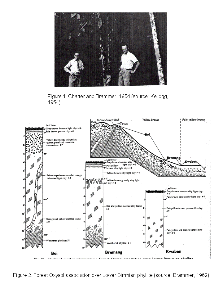
The soil series concepts and soil landscape relationships developed by Charter and his staff utilized the soil genetic model proposed by Neustrev where soil is a function of climate, vegetation, relief and drainage, parent material and age. Soil series concepts were based on descriptions of multiple pedons (approximately 30) for each soil series. Influenced by Milne's work on catenas, soil-hillslope models were developed to illustrate surface and subsurface distributions of soil series, parent materials and vegetation. Various soil series were identified at sampling points using idealized hillslope diagrams, soil horizonation, Munsell color, field determined “Morgan” pH, and a combination field texture and modified Atterburg ribbon test. Other environmental factors such as landscape position, parent material, and vegetation and climatic zones were considered. Soils formed from “drift” materials over residual parent materials and associated with stonelines were frequently observed in roadcuts and other exposures.
During 1954, Dr. Charles E. Kellogg, Director, USDA/SCS Division of Soil Survey documented his observations of Charter and Brammer from his two week visit to Ghana. Kellogg's African Journals, a historical collection at the USDA National Agricultural Library, describe his field visits and personal meetings with Charter discussing tropical soils and other subjects. Kellogg undoubtedly influenced Charter's concepts of tropical soil classification through his “Preliminary suggestions for the classification and nomenclature of great soil groups in tropical and equatorial regions” presentation in the 1948 First Commonwealth Conference on Tropical and Sub-tropical soils.
At the 1954 5th ICSS in Leopoldville, Charter “staunchly defended the traditional genetical system of soil classification” against proposed “formula types of classification.” Charter prepared a brief outline of his proposal for tropical soil classification in a very short amount of time and presented it at a special symposium on soil classification near the end of the Congress. Charter's interim system for tropical soil classification was a hierarchical design with 6 levels: Order, Suborder, Great Soil Group Family, Great Soil Group, Great Soil Subgroup, and Soil Series. Soil series were further subdivided into “soil sub-series” which is nearly equivalent to the various phases of soil series (depth, stoniness, gravel occurrence, etc.). Following the death of Charter in 1956, Brammer published the interim scheme in the Proceedings of the 6th ICSS in Paris. In 1962, Brammer published additional detailed soils information related to agriculture and land use in Ghana.
The comparison of national soil maps through time provides some insights with respect to the development of soil geography and soil classification concepts for a country. In Ghana, national maps with soils information were published as a Geology Map (1947); Great Soil Groups (Provisional; 1958); Great Soil Groups No. 4; C.F. Charter's Preliminary Map of Great Soil Groups (1954); Provisional Map of the Principal Soil Complexes of the Gold Coast; Great Soil Groups (1961); Soil Map of Ghana (1971); and the 1998 Digital Soil Map of Ghana. This presentation will examine the various national maps of Ghana and compare characteristics from the various maps with theoretical developments in the classification of tropical soils in West Africa.

Back to 4.5A History of Soil Science in Developing Countries - Poster
Back to WCSS
Back to The 18th World Congress of Soil Science (July 9-15, 2006)